Home · Bonus issue
Bonus issue · free
The ground, the rivers, and a view from space
This is a free bonus issue, not the usual monthly list of planning decisions. It answers a few practical questions from official open maps and from satellite scenes over Leeds: where the coal high-risk areas sit, how the main becks are classed, which wards ran hottest and greenest last summer, and which grants are actually open. It is not a house survey, not planning advice, and not a formal local-authority search. Always check the official map or the council record before you act.
The maps were made by Terravision (terravision.solutions) satellite mapping. Sources and licences are listed at the end.
1. Coal high-risk areas: which wards sit on the official map?
The ward-level answer. We measured the official Mining Remediation Authority “development high-risk area” map (the 2026 open layer) against the 33 Leeds wards. This is the part of the coal mining reporting area with recorded shallow workings, mine entries and similar features. New development in this defined area should usually be supported by a coal mining risk assessment.
The highest shares are Temple Newsam (28%), Morley North (27%), Burmantofts & Richmond Hill (24%), Farnley & Wortley (23%) and Beeston & Holbeck (22%). Middleton Park, Killingbeck & Seacroft, Garforth & Swillington, Rothwell, Hunslet & Riverside and Cross Gates & Whinmoor all sit around 18–21%. Wetherby and Alwoodley do not show any of this high-risk layer. Adel & Wharfedale and Otley & Yeadon show only a trace (under 0.5%), which may be the edge of a mapped area — check the official map for a specific plot rather than treating those wards as “clear”.
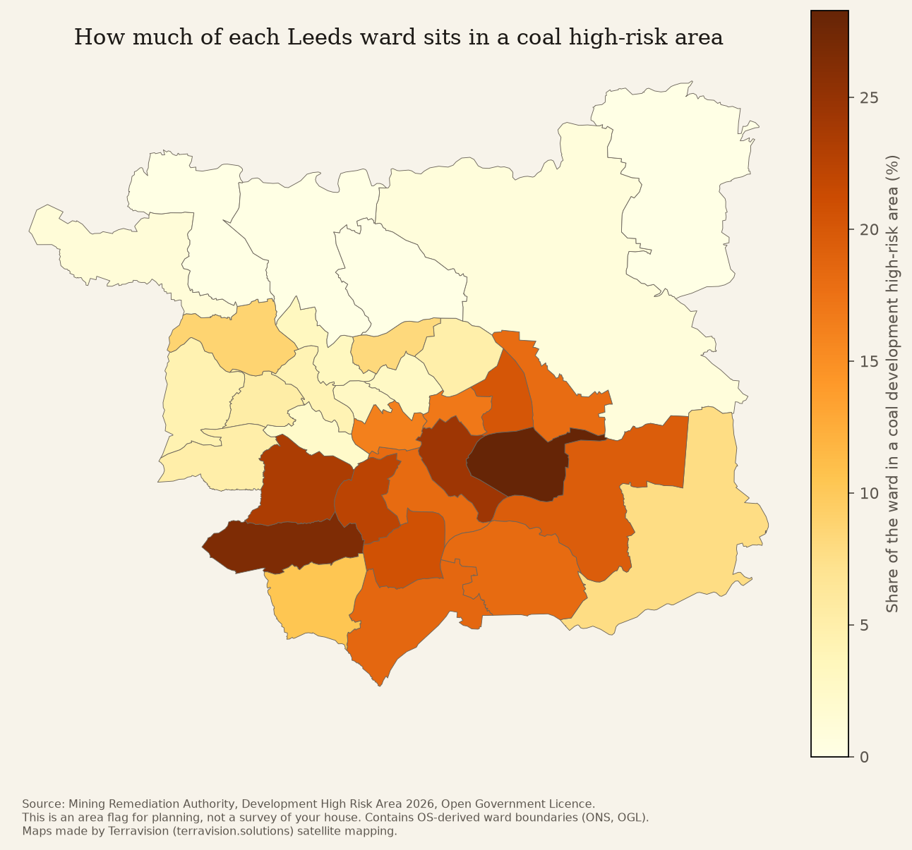
What it means for you. If your street is in one of the darker wards, it does not mean your house is unsafe. It means that, for a new planning application, the council will usually expect a coal mining risk assessment, and that a buyer’s solicitor will often want an official coal mining search (a CON29M), which this issue is not. Plenty of homes in these wards have stood for decades. The official map is about recorded mining features, not a visit to your foundations.
What to do. Look up your plot on the Mining Remediation Authority map viewer. If you are applying for planning permission, read the government’s coal mining risk assessment guidance. If you are buying, ask your solicitor about a proper coal mining search — do not rely on this newsletter.
Want this flagged for a particular house or plot? We’re putting together a £4–£5 house and land check that will include the official coal layer. In the meantime, if you’re viewing a house, the live £4 “what was approved near this house” report covers nearby planning decisions.
We also looked at the European Ground Motion Service, which uses radar satellites to measure very small ground movement. The files need a free EU login to download, so we have not included movement figures in this issue rather than guess. We will add them when we have a real Leeds extract.
2. Rivers and air: what’s officially classed near you?
The ward-level answer. The Environment Agency’s 2025 river classifications (the current Cycle 4 set, Open Government Licence) for water bodies that run through or along Leeds include:
- The River Aire through the city (Gill Beck at Baildon to Wyke Beck, and Wyke Beck to Fryston Beck): overall Moderate, phosphate Poor, chemical status Fail.
- Meanwood Beck: overall Moderate, phosphate Good, fish Good, chemical status Fail.
- Wyke Beck: overall Moderate, phosphate High, chemical status Fail.
- Low / Wortley / Pudsey Becks: overall Moderate, fish Poor, chemical status Fail.
- Lin Dike (towards the lower Aire, east of the city): overall Poor, phosphate Bad, chemical status Fail.
- Oulton Beck: overall Moderate, chemical status Fail.
- Leeds and Liverpool Canal, summit to Leeds: overall Moderate, ecological class Good, chemical status Fail.
- On the north-eastern edge, towards the Wharfe, Thorner Beck and Cock Beck are classed overall Bad.
Almost every water body here — and across much of England — “Fails” the chemical test because of long-lasting substances that turn up nationally. That Fail is real, but it is not, on its own, a local verdict on one outfall. The ecological class and the phosphate class are the more local signals: Meanwood Beck looks in better shape than Lin Dike or the Aire’s phosphate result.
On air, Leeds City Council’s current air quality management area, as recorded by Defra, is the Pool in Wharfedale AQMA around the A658 Main Street, declared for nitrogen dioxide and last amended on 25 July 2024. We have not redrawn that official boundary here. The map to use is Defra’s: Leeds AQMAs on UK-AIR.
What it means for you. A Moderate or Poor river class is an official snapshot of that stretch, not a test of the tap water in your kitchen, and not a claim about a particular factory or farm. If you live by Meanwood Beck, the official picture is better on phosphate and fish than the Aire through the city. If you live near Pool-in-Wharfedale’s Main Street, the council has already said nitrogen dioxide there needs a plan.
What to do. Look up your named beck on the Catchment Data Explorer (Meanwood Beck is GB104027062900). For air, use the UK-AIR page above, or Leeds City Council’s air-quality pages. If you want to help a local river, the Aire catchment partnership and groups such as the Aire Rivers Trust are the people who already work on these stretches — including Wyke Beck.
Want a short report that puts the nearest official river class, the AQMA position and nearby planning decisions against one address? That is the house and land check we are designing, at £4–£5. For planning decisions only, the £3 postcode activity report is live now.
3. A view from space: the hottest and greenest wards last summer
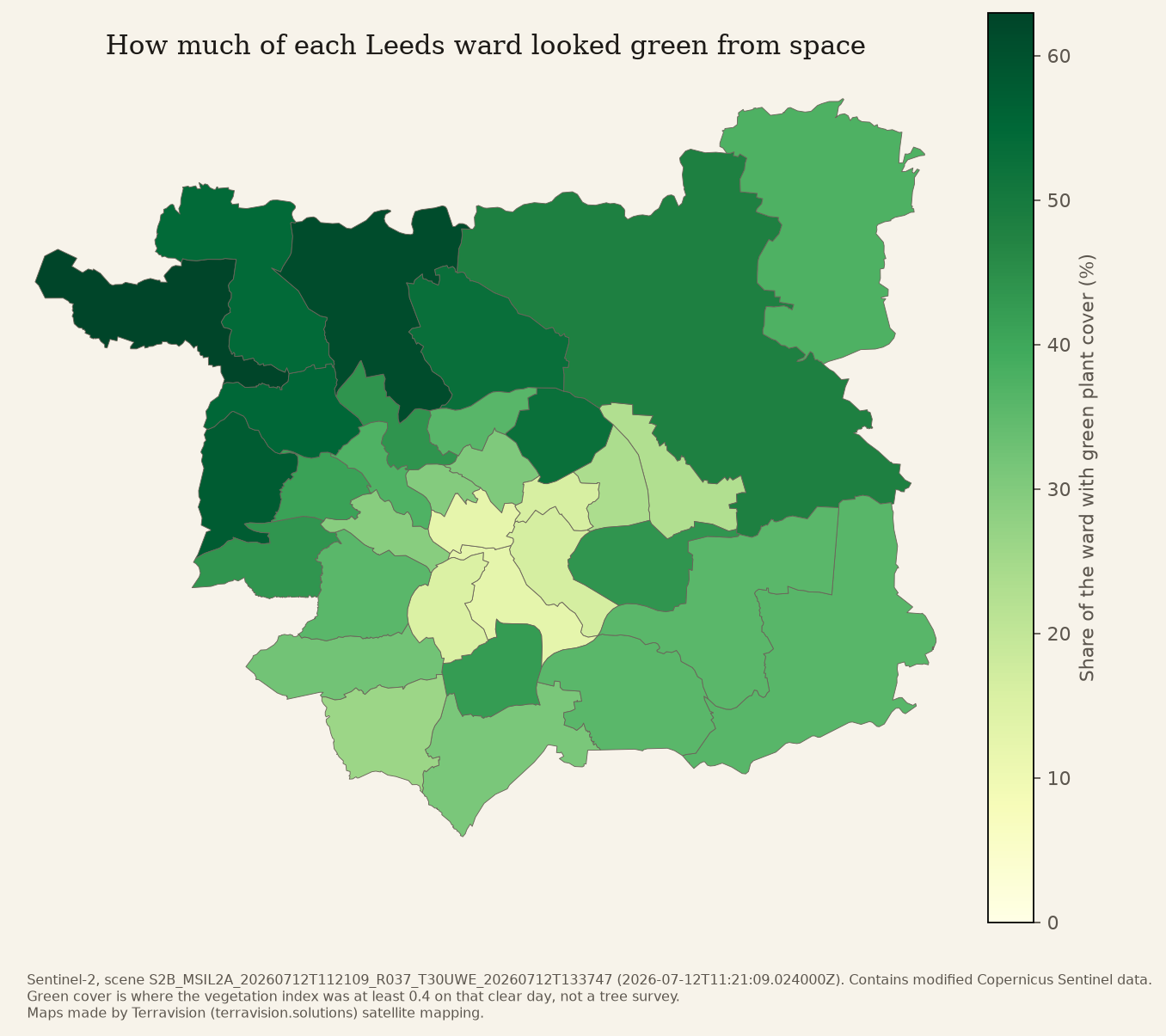
The ward-level answer. On a clear Sunday, 12 July 2026, a Sentinel-2 satellite pass covered every Leeds ward. We measured how much of each ward looked green from space that day (plants and trees, not gardens counted by hand).
The greenest wards were Guiseley & Rawdon (63%), Adel & Wharfedale (61%), Calverley & Farsley (58%), Horsforth (55%) and Otley & Yeadon (54%). The least green were Little London & Woodhouse (13%), Hunslet & Riverside (13%), Beeston & Holbeck (15%), Gipton & Harehills (16%) and Burmantofts & Richmond Hill (17%).
A Landsat satellite measured land surface temperature on Thursday 13 August 2026 at about 11:57 UK time. That pass covered 21 of the 33 wards (the western wards, including Armley, Kirkstall, Horsforth, Pudsey and Otley, were off the edge of the scene, shown grey on the map). Among the wards it did cover, the warmest surfaces were Little London & Woodhouse (42.5°C), Gipton & Harehills (41.9°C), Beeston & Holbeck (41.7°C) and Burmantofts & Richmond Hill (41.7°C). The coolest well-covered ward was Roundhay (38.8°C). These are ground and roof temperatures on a summer late morning, which run hotter than the air temperature on the news.
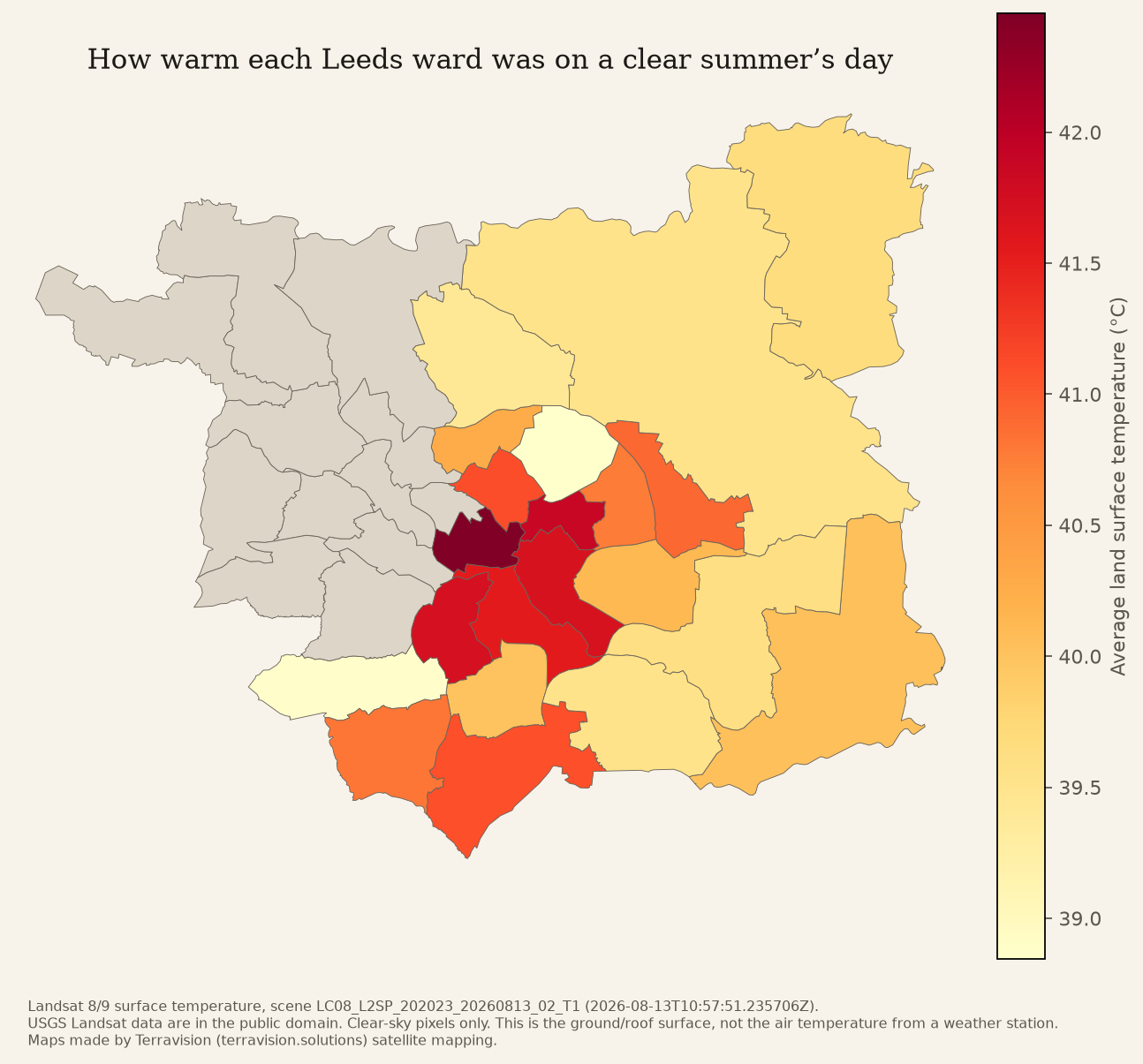
The two pictures agree in a simple way: the inner urban wards that look least green also ran hottest on the August morning we could measure.
What it means for you. This is not a verdict on your street trees or a claim that one ward is “unhealthy”. It is a fair, comparable snapshot of shade, grass and hard surfaces. If you live in Little London & Woodhouse or Hunslet, the official satellites are seeing more hard ground and hotter surfaces than in Guiseley or Adel. That is useful when you think about shade, a green roof, a street tree, or where to walk on a hot afternoon. It is not a reason to avoid buying a house.
What to do. On hot days, the usual common-sense steps still matter (shade, ventilation, checking on neighbours). For a new extension or a loft, the living £4 loft and extension approval-rate pack tells you how similar proposals have fared in the official extract — it does not replace a designer, but it is a sober first look. If you want summer heat and green cover for a specific plot, that will sit in the house and land check.
Want this kind of snapshot for your street, updated when we can? A £1.99-a-month “my street” alert will email you when the new official planning extract is published. The satellite page will be part of the forthcoming house check.
4. Money available (checked 21 November 2026)
These are schemes that, on official pages today, are open or clearly recurring. Several funds people often mention are closed, and we have left them out rather than wave a closed door at you: the Water Restoration Fund (no further rounds planned), Landscape Recovery (closed), the Green Heat Network Fund (Round 12 closed on 25 September 2026; a later round is only pencilled in), and the Property Flood Resilience Repair Grant (it is switched on after particular severe floods, and is not a standing grant you can apply for today). The national Brownfield Land Release Fund 3 is open in much of England, but West Yorkshire councils, including Leeds, are not eligible, because that money is devolved through the Combined Authority.
What is actually in play for Leeds:
- West Yorkshire Housing Investment Fund — £334 million. Approved by the West Yorkshire Combined Authority on 25 June 2026. It is meant to unlock land and stalled housing schemes, with a lean towards brownfield and grey-belt sites (Leeds South Bank is named). This is not a grant a homeowner applies for over the kitchen table. It is for councils, developers and housing partners with a scheme to unlock. Start with the Combined Authority: the 25 June announcement, telephone 0113 251 7272, or [email protected].
- Homes England, National Housing Delivery Fund. Still open as a continuous conversation, not a once-a-year bidding window. It can support brownfield housing and infrastructure through grant, and through loans and equity via the National Housing Bank. It is for bodies corporate — local authorities, companies, registered providers — not individuals or sole traders. In West Yorkshire, Homes England says you should talk to the Combined Authority first about capital grant. Official page (updated 2 November 2026): National Housing Delivery Fund. Enquiries: [email protected].
- Countryside Stewardship Higher Tier. Open now for expressions of interest from farmers and land managers in England, including woodland improvement, agroforestry, and single-focus agreements for species-rich grassland, scheduled monuments, traditional orchards and wet grassland. Payments vary by the actions you take on. An expression of interest is not a guaranteed agreement. Official page (updated 19 November 2026): Funding for farmers, growers and land managers.
- Water Environment Improvement Fund (recurring). This is the Environment Agency’s annual partnership fund for river and wetland projects. The 2026 Local Water Environment Grant window closed on 25 September 2026. If you are a local authority or a third-sector group with a catchment project, the route for the next year is to talk to your Environment Agency catchment coordinator and get the project onto the Medium Term Plan. It is not a household grant.
If your plot is a former industrial site, a farm, or a community river project, those first conversations are the useful next step. If you just want to know what sits on your street, the reports below are the small, self-serve option.
Get the digest, or a report for your street
The monthly planning digest remains free: subscribe to What’s Being Built in Leeds. Issue 1, on October’s official decisions, is already up. The website is whatsbeingbuiltleeds.pages.dev.
Live small reports, emailed within 24 hours (alerts start at the next monthly extract):
- Planning activity report for a postcode — £3
- What was approved near this house — £4
- Monthly postcode alert — £3/month
- My street monthly alert — £1.99/month
- Loft and extension approval-rate pack — £4
- Refused applications pack — £3
- This month in your ward — £2
- Support the newsletter — 99p
The house and land check described above is not on sale yet. When it is, it will pull these official layers and the satellite snapshots onto one plot, for £4–£5.
Sources and licences
- Coal development high-risk areas: Mining Remediation Authority, 2026 open layer, Open Government Licence. Measured against ONS wards (May 2025), also OGL, contains OS data © Crown copyright and database right 2025.
- River classifications: Environment Agency, WFD Cycle 4 classification 2025, Open Government Licence. © Environment Agency copyright and/or database right.
- Air quality management area: Defra UK-AIR, record for Leeds City Council, checked 21 November 2026.
- Green cover: Sentinel-2 scene S2B_MSIL2A_20260712T112109_R037_T30UWE, 12 July 2026. Contains modified Copernicus Sentinel data.
- Land surface temperature: Landsat 8 Collection 2 scene LC08_L2SP_202023_20260813_02_T1, 13 August 2026, 10:57 UTC. USGS Landsat data are in the public domain. Twenty-one of 33 wards were on that pass.
- Maps made by Terravision (terravision.solutions) satellite mapping. Grant entries were checked against official pages on 21 November 2026.
Get the next issue free
Free. We only email people who sign up. A plain-English reading of official Leeds planning decisions, once a month.
Read next